-->
Location
Nubra Valley is
located North of Leh at a distance of 120 kms from Leh. Apporach to Nubra
Valley is by road from Leh across Khardongla (18383ft)-the world highest
motorable pass. Leh is the principal district & town of Ladakh in Jammu
& Kashmir state. Average altitude of Nubra Valley is 10000 ft from sea
level.
 |
| Nubra Valley |
Bordering Chinese
Turkistan (Xianjag) on the North & Pakistan on the west, Nubra Valley
is located between Karakoram Mountain on the North & Ladakh Mountain on the
South. In history, Nubra was called Ldrumra. In vernacular language Ldrumra
means the Valley of flowers. Geographical features like Cress cross running
rivers, green belt river basin of seabuck forest bearing berries, lofty &
majestic mountains of Karakoram & Himalaya, full blown vegetated Villages
(some truely oasis of desert), silvered colour sand dunes, white & black
pebbles all together join to romance & compose Nubra Valley the Valley of
flowers.
Mountains, Peaks & Glacier
Karakoram
Mountain houses the highest peak of J&K state and highest & largest
glacier of the world. 17000 ft high & 11 kms long Siachen glacier is in
Karakoram. The highest peak- Saser Kangri which is 25344 ft (7680mts) is also
in Karakoram. Rimo (Rimo 1,2,3- the group of peaks), Saser 1 & 2,
Mamosthong, Indira Col. Argalas & several other peaks (all above 25000ft)
are also in Eastern Karakoram. The K2 - the 2nd highest peak of the world is in
Pakistan Karakorum. India’s Himalaya is linked with Hindukush of Afghanistan of
Central Asia by Karakoram Mountains.
Geography & Karakoram
Geographically Nubra
is linked with Turkistan of Central Asia. Bordering China across karakoram pass
is Chinese Turkistan (Xianjang). Yarkend is nearest & principal town of
Chinese Turkistan (Xianjang) across Karakoram pass. Karakoram is a Turkish
word. It means black pebbles. And in fact the whole of Nubra is dotted with
black & white pebbles along the river basin. Seabuck throne forest
naturally grown along the riverside is the breeding ground for Bactrian
camels. Bactrain camels were brought to Nubra Valley by Hor, the Turkish
muslim during the Silk Route trade before 1962.
Shayok & Siachen River
 |
| Shayok river |
Shayok &
Siachen are Twin Rivers of Nubra Valley. Shayok River originates from two
glacier of Karakoram-Chhong Khomdan & Kichik Khomdan. The Turks have named
it as big source & small source of water. Flowing from the North side
Shayok River takes Southeast direction up to Shayok village near Durbuk &
then turns South West direction. Siachen River originates from Siachen glacier.
It is a tributary of Shayok River and known as Nubra River also.
*Confluence* of two river from the broadest central part of Nubra Valley. And
the landmark of this place is the Sand Dune & forest of Sumoor &
Lakjung village. Deskit village is across the confluence of river on the
Southern Side & Tegar Sumoor village are on the Northern side facing each
other. A part of Karakoram Mountain connecting Siachen glacier cut across Nubra
Valley and ends up near the confluence touching both the rivers. This is most
beautiful scene of Nubra Valley. From here onwards Shayok River
flow westward in to Baltistan taking its course through Bogdang
&Turtuk village. The villages are irrigated and fertile, producing wheat,
barley,peas,mustard for oil, and a variety of fruits and nuts,including
apple,apricot and a few almond trees. The region is rich in rare floristic
species,being part of one of the world’s biodiversity hot spots, the
Himalayas(which contain an estimated 10,000 species of plants, of which about
3,160, belonging to 71 genera are endemic). Some 1,195 species of flowering
plants are endemic to the Western Himalayas of which 700 plant species have
been recorded from this region. The extreme climatic conditions have resulted
in less natural vegetation, with sparse shrubs and trees. There are three main
elements of floristic diversity: alpine, desertic, and oasitic. The alpine
herbs grow along the edges of melting glaciers. The desertic type covers the
upper slopes and valleys, while the oasitic type is found encircling aquifer.
Siachen glacier lies
to the north of valley. The Sasser pass and the famous Karakoram pass lie to
the northwest of the valley connecting Nubra with Xinjiang. Previously there
was trade passing through the area with east Turkistan and Central Asia joining
the main silk route.
History of Nubra Valley
Nubra valley of
Ladakh is called”LDHUMRA” or the “valley of flowers”. The historians
from immemorial have described the beauty of this valley in different
languages. Its history is linked with the history of Central Asia as
geographically its borders are linked with Chinese Turkistan of Yarkand and
Khotan. Central Asian traders were called as Hor in Nubra Valley. Hor were
Turkish musilm who used to travel Central Asia and Tibet through silk route.
Nubra Valley falls on the Silk Route and people of Nubra used to
mingle with products like turquoise stone, carpets, rugs etc and in exchange
for local food product like Tsampa, milk, butter, fodder etc. Local Charagas
like Tsogs and Nyangskors were utilized by the Hor for their animal transport
like camels, mules and horses. Some locals also were hired by Hor to carry
their merchandise to Leh and Tibet across Diggar and Khardungla. Sometime they
also accompanied Hor up to Karakoram pass.Therefore it is very interesting to
look at its history in a broader perspective most of which is hidden in the
local intangible oral tradition.
History of Samstanling Gonpa
 |
| Maitreya Buddha, Diskit Monastery |
The earliest record
on Samstanling Gonpa goes back to 1843 when Lama Tsulim Nimma(1st incarnation)
visited this monastery. The ideal location of this place mesmerized him and he
chose to retreat and meditate here. Located at the elevation of 500 and 1000ft
from the twin village of Summor and Tegar repectively, it presents a tranquil
and serene environment far away from the squalor of the Village unfurling its
natural beauty. The monastery is located at such a dominating state of
elevation that the entire central part of Nubra Valley can be viewed both
towards west (up to Charasa place) and south (up to Deskit Gonpa). The
beautiful scenery of majestically high snow capped mountain ranges (Ladakh and
Karakoram) of western Himalayas and green basin of twin rivers (Shyok and
Siachen) of the valley from the monastery is awfully breathtaking. And this is
the only major monastery in Ladakh, which is surrounded by high vegetation with
a varied flora. Vegetation consists of apple, poplar, willow and juniper trees.
The land of this monastery is irrigated by Summor Tokpo (rivulet). Of course,
wide spread growth of sea buck thorn bushes are below and all along the stream
fed irrigated channels of Summor and Tegar village. The technique of farming on
the slope of hills in the form of a flight of steps-an
innovative way of irrigation, so that the flow of water remains continuous
despite the irregular rocky surface. The hard work paid off and the granary
became full to the brim with seeds and pulses spreading the aroma of happiness.
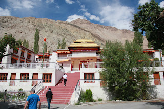 |
| Samstaling Monastery, Nubra Valley |
A magnificent cave
(now sealed) is located beyond the wall of Dukhang Nyingma (old temple), dark
interior shrouded in mystery, which lured lama Tsultim Nimma to meditate for a
long time. For the lack of written documents exact details of history of this
cave are unavailable. However it is true that this monastery was founded
by Lama Tsultim Nimma (1st incarnation). Samstanling Gonpa named by
Panchen Ripochey on the request of Lama Tsutim Nimma 1st incarnation during an
audience in Tibet.
After lama Tsultim
Nimma (1st incarnation), the reign of this monastery was taken over by Lama
Tsultim Chospel (Stars Rinpochey, 2nd incarnation). His place of retreat was
Lhastsas in summor village, which is below the monastery on the other side of
rivulet. However he was married and his wife was popularly known as Abey sCham
who was equally held with high esteem. There was dairy farm and kitchen garden
maintained by the family of lama Tsultim Nimma from where milk and
vegetables were supplied to monks of Samstanling Gonpa on daily basis. Those
were flourishing days in the history of Samstanling Gonpa. Thus, the Lhastas family
contributed immensely in the building the heritage of Samstanling monastery.
The present lama Stras Rinpochey is held with high regards as his contribution
in building the tradition of this monastery is commendable. The present Stars
Rinpochey (known as Jetsun Thupten Nimma Lungtok Stanzin Nurbu) who is 3rd
incarnation of Stars Rinpochey of twin monastery of Rizong and Samstanling, is
holding the position of Golden Throne or Gaden Tri of Gelugpa tradition of
Tibet since October 2009. He has been enthroned on the highest seat of Gelugpa
tradition as 102 Gaden Tripa Rinpochey after the announcement by His Holiness,
the 14th Dalai Lama of Tibet, Govt in Exile on Oct 26, 2009.His Holiness, the
Dalai Lama took the opportunity to talk about the New Gaden Tripa during an
event at Norbulingka Institude in Dharamsala to mark the release of set of his
biographies on an official ceremony of new Gaden Tripa.
Yet another
fortunate chapter added to the history of Samstanling Gonpa is during the era
of Stars Rinpochey (present Gaden Tripa) who was holding charge of Regent of
Spituk and Sankar Gonpa, the reincarnation of 17th of Bakula has been
identified by His Holiness, the Dalai Lama. Therefore the golden
history of Summor and Tegar village is written with the blessing of Lord
Buddha, His holiness, the 14th Dalai Lama and Gaden Tripa(Stras Rinpochey).
 |
| Double hump camel of Nubra Valley |
Once serving as the
arteries for Central Asian trade linking Silk routes, presently, against a
spectacular backdrop of natural aesthetics, the valley preserves the pristine
glory of Buddhist pantheon. Making foray into the hearts of itinerants, the
valley makes soulful rendition of divinity. As the valley is very green and
clean, we would like to keep it in that way. So, don’t litter and respect the
local culture prostrating before the Buddha.


